The White Mountains
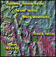
Located in east central California just north of Death Valley, and on the western edge of the Great Basin, the White Mountains rise to a respectable altitude of 14, 246 feet.
Yet they remain in a rain shadow of the Sierra Nevada located a few miles west across the deep Owens Valley. As Pacific storms move eastward, the Sierra simply takes the majority of moisture, leaving the White Mountains with strong dry winds. Annual precipitation is less than 12 inches, most of which arrives as snow in winter. On a summer's day the amount of precipital moisture in the air is about half a millimeter, the lowest ever recorded anywhere on earth. But these very hardships contribute to these mountains bringing forth trees so beautiful, so ancient they surpass the majestic Giant Sequoia of the Sierra by more than a millennium!
Download a spectacular White Mountains landform
map image 369k.
The White-Inyo Range extends from Montgomery Pass south-southeastward
to Malpais Mesa in the Owens Lake area, a distance of 110 miles.
The mountains here rise from valleys on the east and west. The separation point between White and Inyo mountains is placed at the Westgard Pass road (Hwy 168) a division with no geographic importance. This range reaches its greatest width (22 miles) east of Bishop. The rise from the Owens Valley floor at 4,000' to elevations of more than 14,000' is abrupt, occuring within a 12 mile line. These ranges have more ties with plants and animals to the east in the Great Basin, than their close neighbor the Sierra Nevada, only 10 miles westward.
Climate
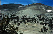
Weather here is cold and dry. The average max.-min. temperatures range from about 70°F (21°C) to 37°F (3°C) at the base, and from 36°F (2°C) to -26° (-32°C) in the alpine zone. Precipitation averages 4 in (10 cm) at its base to 20 in (50 cm) mostly as snow, along the crest. Due to the varied topography, precipitation can and does differ greatly in localized areas. Winds blowing along the crest can blow most of the snow from some areas, leaving little for trees like the bristlecone at the treeline (11,200 ft.). Thunder and lightning storms occur frequently in the high country. Winds are strong at the crest, both summer and winter.
The dry climate and high altitude make this region a rare environment. The rapid changes in elevation create abrupt habitat and species changes. The soil quality is poor, and at its poorest in the alpine zone. This factor combined with a short growing season, results in sparse and delicate flora. Recovery from disturbance is slow, said to take more than 100 years! This is truly an area that one must be careful in preserving.
Driving along Hwy 395, and looking up at the White-Inyo range, it's appearance is somewhat barren and inhospitable, but once there we are gifted with sights and beauty unimagined from below. In August the wildflowers are abundant, the night sky clear and breathtaking; and it is so quiet here you can actually hear the wingbeats of small birds! The bristlecones are reason enough to travel here, and with the abundant flura, wildlife, and vistas, we are compelled to return.
Geologic Makeup
The geologic makeup of the White Mountains is of quartzitic sandstone and granite bedrock. A large part of the soils on these slopes have been swept away by the extreme conditions. Also present are extensive outcrops of
dolomite
(limestone) a very ancient rock first laid down under water 500 million years ago, then slowly uplifted through time. Numerous fossils of this period can be found here. It has been speculated that one could have walked chest deep across the early
Paleozoic
sea located in the region at that time. The dolomite is low in nutrients but of a higher moisture content than the surrounding sandstone. Because these soil types inhibit the growth of other plants, they provide a competition-free arena for the slow-growing bristlecone pines.
The spectacular panoramic views of the Sierra Nevada along with the Ancient Bristlecone Pine Forest are the principal attractions for tourists. Due to the lack of water (you must bring your own), camping and other recreational activities are light.
Getting there:
-
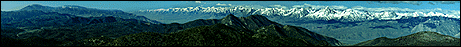
Reaching the White Mountains and the Ancient Bristlecone Pine Forest from Bishop, California is about a 1 hour drive. Travel south (14 mi.) on hwy 395 to Big Pine, then east up hwy 168 to the White Mountain Road (13 mi.). Here we turn left and continue the remaining 7 miles up to Schulman Grove (10,100 ft.). Several vista turnouts are located on the White Mt. Road, the most spectactular being Sierra View Overlook (see panoramic photo above).
The trip is surprisingly simple considering the rate of climb, but large moble homes or trailers should not attempt this journey because of the tight curves and grade.
An excellent map to have on hand is the AAA "Guide to Eastern Sierra".
-
An additional 13 miles beyond Schulman is required to reach Patriarch Grove (11,200 ft.). This road is gravel, rough in places, but can be easily done with the family car. We are rewarded with sights you cannot find elsewhere. Patriarch Grove is located in a large open bowl, exposed to wind and weather. And yes, along with the astounding trees, you will find toilets here, picnic tables and an outdoor display case.
- Be sure to have plenty of gas, a well tuned engine and adaquate coolant in your radiator.
- Check the current weather forecast for Bishop, California. Remember that Patriarch Grove is 8000' above Bishop and the temperature will be considerably cooler.
Camping:
- Camping is allowed at the Grandview campground (8600 ft.), free of charge, on a first come basis. 36 sites. Open May through October.
- There are 4 group camps (7200 ft.) located at the entrance to White Mt. Road. Open all year by reservation only. Phone: (800) 280-CAMP
- There is no water here. You must carry all you will use during your stay. As a family of three (tent camping), we use 5 gallons per day. Dehydration is common in this dry climate, so don't skimp on your water intake. Make yourself drink, even if you're not thirsty. I personally believe that keeping your hydration level up will also help prevent the headaches that can occur at these altitudes.
-
Sun screen lotion, a hat, sun glasses with UV protection are needed due to the greater exposure to ultraviolet radiation.
-
Always carry water on any hiking trip.
-
For more information contact:
White Mountain Ranger District
798 North Main Street
Bishop, California 93514
(619) 873-2500
|
The Ancient Bristlecone Pine Forest:
Because the forest is such a special place, everything possible must done to preserve its fragile and irreplaceable environment. This area has been classified as a Botanical Area and is set aside for scientific research and public enjoyment. The following are rules established by the U.S. Forest Service:
- All natural features are protected. No wood, rocks, or plant material may be removed. Each piece of wood, regardless how small, maybe of great importance in the scientific research of the Bristlecone Pine. Scientific permits are required to collect plant or rock specimens.
- Archaeological sites are a vital record of the past. Disturbing sites of artifacts destroys these traces of cultural history and is unlawful.
- Because of fire danger and soil compaction, all camping, stove use outside vehicles, and campfires are prohibited.
- To prevent tire track damage which remains on the landscape for years, vehicles are to drive only on established open roads. Park in designated areas or stop as close to the road edge as possible.
- Bristlecone Pine tree roots are shallow and easily damaged by impact and soil erosion. Hikers must remain on trails at Schulman and Patriarch Groves: Do not short-cut trail switchbacks.
Table of Contents