The program arose out of simple curiosity to see what a population of landscape spectral signatures might look like. I wrote the software so that a single signature is a line on a chart, connecting six points in spectral space. The program then steps through a selected region of a TM image displaying each signature in turn as a colored multi-jointed line and then the whole population as displayed as a polygon with approximately twelve nodes in the chart of spectral space (Plate 1).
The original question I asked in writing the code was, what places in our region are like the core of the Arcata City Forest, from the point of view of the Thematic Mapper?I propose to rewrite the software in Java for this project, make it more graphical and easy to use and add an important new capability. It is possible that in the future, people and machines are going to an increasing extent to be perceiving reality as multispectral because more information is derived from the same instance of viewing ones surroundings that way. As ccd devices with sensitivity outside of the normal human visible range become cheaper it becomes apparent that there is nearly free information being offered by nature at all times that we are not making full use of. This was impressed upon me when in another project I was delighted to find that a NIR filter over a standard digital camera produced acceptable imagery.
If
one allows this speculation as to the utility of a multispectral viewpoint,
then arrays of multispectral signatures will surely tell even more than an individual
multispectral signature. By use of arrays I mean deriving increased
understanding about the significance of a given spectral signature in geographic
space from the presence and location of other similar or differing spectral
signatures near it. Here we are trying
to develop a topology of spectral signatures.
With this in mind I Propose to modify my software to allow a simple graphical querying of a TM image in the form of describing three spectral signatures and requesting, tell me where riparian coastal vegetation is surrounded by pasture with both intersected by a road. The purpose of such an example query could be to determine likely spots for deer to be crossing a road while following a stream course from upland areas to the Arcata Bay.
Java has been selected as the development language for this project because of its object orientation. Analysis and visualization tools are becoming based on the object oriented model (Pundt and Brinkkotter-Runde, 1998) and data itself is being seen as a collection of objects (Camara et al, 1996). Java provides these approaches to be fully realized as it is widely known to be completely compliant to the object model of reality. The results of this project can set the stage for development of other more powerful visualization tools due to the reusability of classes developed during this project, with future projects (Silver, 1995). The available Java integrated development environments, one of which I intend to employ, are becoming quite rich in tools if not any easier to use and will provide my medium to work in for this project.
The proposed timeline for this project is as follows:
Camara, G., R. Souza, U. Freitas and J. Garrido, 1996. Spring: integrating remote sensing and GIS object-oriented data modelling, Computers and Graphics, 20(3):395-403.
Nieves, A., D. Villegas, J. Casadesus, J. Araus and C Royo, 2000. Spectral vegetation indces as nondestructive tools for determining durum wheat yield, Agronomy Journal, 92(1):83-91
Pundt H. and K. Brinkkotter-Runde, 1998. Visualization of spatial data for field based GIS, Computers and Geosciences 26(2000):51-56.
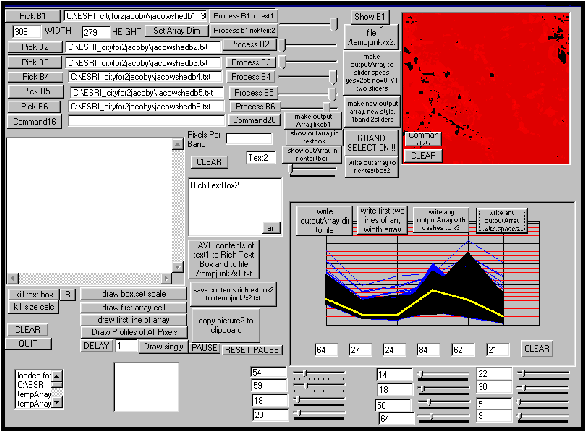
Plates
Plate 1. Spectral Explorer (version 25) The red area is a display of one of the six
bandsimported on the upper left.
The white area on the left would display the raw integer values of a
given band if the file was was smaller than the 309 x 279 values indicated at
upper left. The chart at the lower right is a representation of the population
of pixels imported and the yellow line is the spectral signature of a single
pixel. The twelve sliders are used to
delineate a zone of interest within the total population of signatures. Note that this is experimental software, not
a finished product.
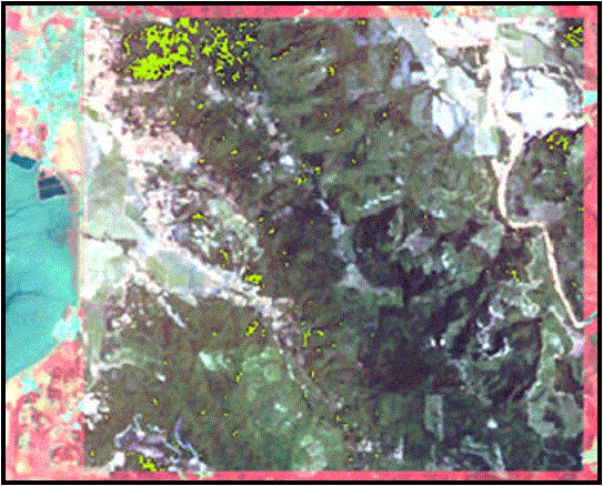
Plate 2.
Results of use of Spectral Explorer to search for exact matches to the
spectral signature of what I arbitrarily determined to be the core of the
Arcata City Forest. The large darker
green area is the mask created by Spectral Explorer with its successful matches
highlighted in bright green. A large
green clump at upper center is the forest itself. The bright reddish area at the borders is the underlying Landsat
TM image.
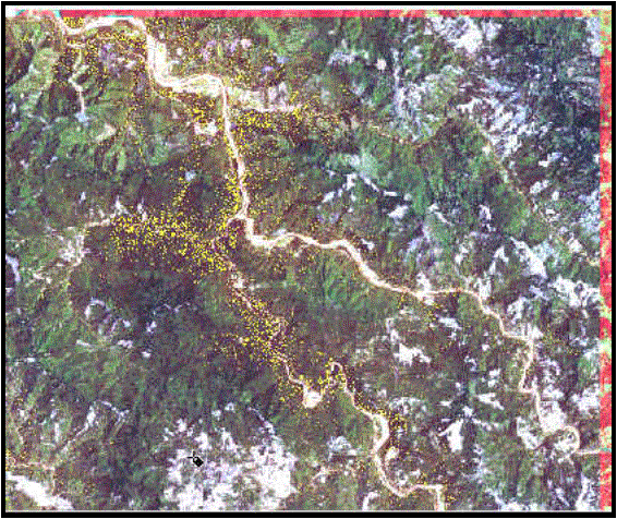
Plate 3. Applying the technique used in plate two led
to few results outside the immediate Arcata area, but minor adjustment of signature
matching parameters revealed what is probably the old growth redwoods found
in the series of state parks adjacent to highway 101 in southern Humboldt County.
These are highlighted in yellow. Interestingly,
these are a tiny subset of all the forest vegetation in the area.