Politicians have never seriously debated
whether groundwater resources are sufficient in the south
Santa Rosa plain. In fact, they seem to ignore the issue.
But our underground water source appears to be seriously
depleted. Steve Carle Ph.D., a local geohydrologist demonstrates
this severity with readily availble sources of information
and provides us with ample lines of substantiation.
Groundwater Overdraft
in the South Santa Rosa Plain
Most landowners in the unincorporated
community of Penngrove rely on groundwater for water supply.
Rohnert Park and northern Penngrove both share the same
groundwater resource, the aquifers located in the southern
portion of the Santa Rosa Plain subbasin (DWR 1982; DWR
2003).
However, there are no impervious
geological barriers dividing the Santa Rosa Plain and Petaluma
Valley aquifer systems. Most of the basins and subbasins
in Sonoma County are hydraulically connected below the
ground surface, as indicated by U.S. Geological Survey
and DWR maps (USGS, 2003; DWR, 1975).
As a result of excessive
pumping by the City of Rohnert Park and other factors discussed
below, more groundwater is being pumped out than what is
naturally put back or “recharged” into the
aquifers. In hydrologic terms, this is called “overdraft.” According
to the California Department of Water Resources (DWR,2003):
A basin is subject to critical conditions of overdraft
when continuation of present water management practices
would probably result in significant adverse overdraft-related
environmental, social, or economic impacts.
For over 25 years, excessive
groundwater pumping within the City of Rohnert Park has
induced critical conditions of overdraft, causing outrageous
water level declines and dry wells in Penngrove.
Rohnert Park EIR
Groundwater Modeling Study
In the process of expanding
its “Sphere of Influence” into Penngrove and
other unincorporated areas, the City of Rohnert Park had
to evaluate cumulative long-term impacts of its groundwater
pumping from over 40 municipal wells since the late 1950s.
A groundwater modeling study was included in the “Hydrology,
Flooding, and Water Quality” section of the “Revised
Draft Environmental Impact Report” (EIR) for the
City of Rohnert Park’s General Plan 2020 (RP, 2000).
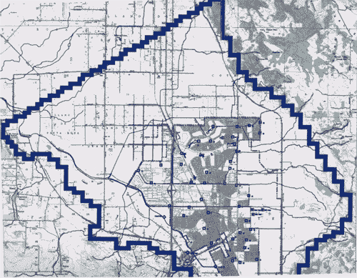
The groundwater study focused on the southern portion of
the Santa Rosa Plain subbasin (the Subbasin) outlined in
blue in Figure 4.10-3 of the EIR and shown below.
The Subbasin encompasses
the City of Rohnert Park, the City of Cotati, Sonoma State
University, and outlying unincorporated areas including
the northern portion of Penngrove (est. 1882). Rohnert
Park (est. 1957), with a population of 42,500 in January
2003, is by far the largest water user within the Subbasin.
Rohnert Park currently relies primarily on groundwater
and secondarily on contracts from the Sonoma County Water
Agency (SCWA) for water supplies.
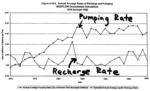
In Figure 4.10-2 of the EIR
(see above), average annual recharge rates are compared
with annual average pumping rates for the City of Rohnert
Park’s municipal wellfield. Since 1975, the pumping
rate has exceeded the recharge rate, increasing from 1.7
mgd to an average of about 4.3 mgd since 1984. By its own
admission, Rohnert Park extracts groundwater in gross excess
of the estimated average recharge rate of 1.60 mgd (RP,
2000, p. 4-146).
The modeling study indicates that the cumulative overdraft between 1975 and
1999 exceeds 20 billion gallons. Unfortunately, the modeling study ignored
groundwater level declines and pumping in areas in rural areas within the
Subbasin such as northern Penngrove. Adding up pumping by the City of Cotati
(~0.4 mgd), Sonoma State University (~0.16 mgd), and northern Penngrove (~0.45
mgd), total pumping within the Subbasin in 1999 is conservatively estimated
at 5.3 mgd, which is over three times greater than the modeling study’s
estimated recharge rate of 1.60 mgd. Considering areas outside Rohnert Park
city limits and within the Subbasin, the cumulative overdraft between 1975
and 1999 may exceed 30 billion gallons.
Why “Safe Yield” is
not Sustainable
Most policymakers assume
that “safe yield” is a “sustainable” pumping
rate equivalent to natural recharge. However, this assumption
is flawed because it does not take into account discharges
of groundwater into streams, springs, or marshes. An editorial
by Marious Sophocleous in the prestigious hydrogeology
journal, Ground Water, explains (Sophocleous, 1997):
If pumping equals recharge, eventually streams, marshes,
and springs dry up. Continued pumping in excess of recharge
also eventually depletes the aquifer.
A better definition
of safe yield would address the sustainability of the
system – not just the trees, but the whole forest;
not just the fish, but the marine food chain; not just
the ground water, but the running streams, wetlands,
and all the plants and animals that depend on it.
According to its own EIR, the City of Rohnert Park’s groundwater pumping
is in gross excess of safe yield defined by either natural recharge or Sophocleous’s “sustainability
of the system” concept.
Water Level Declines
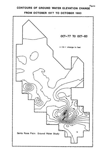
In the 1950s, groundwater
levels ranged from 5 to 20 feet below ground surface in
the vicinity of Rohnert Park (Cardwell 1958). DWR (1987)
mapped a “cone of depression” in the vicinity
of Rohnert Park, including the largest water level declines
between 1977 and 1983 shown below:
Parsons Engineering Science,
Inc. (1995) noted drops in water levels as much as 130
feet between the 1960s and 1983. Between 1975 and 1999,
water levels declined by 100-150 feet along the eastern
boundary of the proposed Urban Growth Boundary, most of
which presently consists of rural lands within the Penngrove
community (RP, 2000, p. 4-146).
According to unpublished 1996-2002 data from the City of Rohnert Park, water
levels in some municipal wells occasionally drop to over 300 feet below ground
surface. The full scope of the impact on outlying areas, including Penngrove
remains uncertain due to lack of a coordinated effort by local agencies and
DWR to examine existing data and collect new monitoring data.
Adverse impacts to landowners
are extensively documented by well surveys conducted by
Penngrove resident John King in 1999 and 2003. In recent
years, some Penngrove residents have resorted to trucking
in water.
Groundwater Management
According to DWR (2003):
Groundwater management …is the planned and
coordinated monitoring, operation, and administration
of a groundwater basin or portion of a groundwater basin
with the goal of long-term sustainability of the resource.
Penngrove straddles the
watershed divide between the Santa Rosa Plain subbasin
and the Petaluma Valley basin. Penngrove is also vulnerably
sandwiched between two large pro-growth oriented municipalities,
Rohnert Park and Petaluma.
DWR (2003) identifies the
Sonoma County Water Agency and the cities of Rohnert Park
and Petaluma as the local agencies responsible for groundwater
management in the regions near Penngrove.
No groundwater management
plans have been initiated by any of the responsible local
agencies in Sonoma County (DWR (2003). In fact, SCWA and
the North Marin Water District (which consumes 23% of SCWA’s
water allocation) are two of the few water agencies in
California on record as having “no interest” in
groundwater management (DWR, 1999).
Yet SCWA currently pumps
over 5 million gallons per day, enough to supply about
30,000 residents, from its three “emergency wells” in
the Santa Rosa Plain. And why are these emergency water
supplies being pumped out (and exported to Marin) without
a drought and without a plan for groundwater resource sustainability?
Sonoma County’s local
governmental power structure facilitates an opportunity
for cities to overdraft the groundwater resource to the
detriment of the rural areas because the Supervisors, who
have the ultimate power in land use decisions, also serve
as the Board of Directors for the SCWA:
The cities vote in the
Supervisors (the Water Board).
The Water Board (the
Supervisors) rules SCWA, which supplies water to the
cities.
The cities rely on growth
for revenue, and the Supervisors (the Water Board)
oblige on land use decisions.
The cities want more
water, and the Water Board (the Supervisors) obliges
on water supply decisions.
The urban thirst for water induces
groundwater overdraft into rural areas, and the Water
Board, Supervisors, and cities shirk responsibility for
groundwater management despite having the legal authority
to do so.
It remains to be seen whether
new state laws requiring proof of sufficient water supplies
for new developments will have any impact on the power
alliance between the Cities and the SCWA.
The State has provided the
County, cities, and SCWA with a step-by-step guidebook
to integrating water and land use planning and groundwater
management.
Alternatives to local management
of groundwater resources are lawsuits and adjudication.
Adjudication is a court decision to strip local agencies
of control and govern the basin through a court-appointed
watermaster. Seventeen basins in California are adjudicated.
The only effective groundwater
management action to date has been a lawsuit filed in August
2000 by John King and the South County Resources Preservation
Committee of Penngrove over the Rohnert Park EIR.
As a condition of a settlement
agreement, the City of Rohnert Park was required to cut
pumping in half before developing outside 1999 city limits
and to request that SCWA develop a groundwater management
plan for Rohnert Park. SCWA rejected this request, confirming
that neither Rohnert Park nor the SCWA are willing to take
on their responsibility to manage groundwater resources
in a sustainable manner.
The Sonoma County Local
Agency Formation Commission (LAFCO) is charged with a state-mandated
oversight role to stop misuse of land resources by discouraging
urban sprawl and preserving agricultural land resources.
LAFCO approved a gross misrepresentation
available water resources with complete ignorance of the
location of State-identified natural recharge areas. The
Rohnert Park EIR erroneously stated a “planned” average
annual allocation of 15 mgd from future SCWA contracts.
According to SCWA (2000),
Rohnert Park is allotted a “maximum monthly delivery
rate” of 15 mgd with an annual limit of 6.7 mgd (not
15 mgd), which is less than 1999 demand of 6.9 mgd (RP,
2000).
Rohnert Park trumped up
so-called “planned” future annual SCWA allocations
by a factor of 2.5. However, both the 15 mgd and 6.7 mgd “planned” future
SCWA allocation figures have proven to be “paper
water” since the Friends of the Eel River Appellate
Court decision of May 16, 2003.
SCWA General Manager Randy
Poole admits that the cause of “temporary impairment” is
no longer only a matter of transmission capabilities, but
of water rights. “Contemplated” SCWA water
supply increases of 35% are not legally secure (they never
were), and current SCWA water rights may only suffice for
a few more years of urban growth in Sonoma and Marin counties.
Cities like Rohnert Park,
Petaluma, and Santa Rosa based their urban growth plans
through 2020 on the paper water of “contemplated” Eel
River diversions - water supply projections that were not
legally secure.
Next Development
Target: Natural Recharge Areas
Much of the past, current,
and future environmental impacts related to groundwater
overdraft hinges on the fate of future land use decisions
in State-identified natural recharge areas. Rohnert Park
hopes to bail itself out of a multi-million dollar budget
crisis, in large part, by developing lands identified by
DWR (1975) as natural recharge areas.
The impact of covering over
prime natural recharge areas with urban sprawl was not
evaluated by Rohnert Park’s EIR, either. Large tracts
of State-identified recharge areas are now engulfed by
Rohnert Park’s “Sphere of Influence.” The
City of Rohnert Park has specific plans to pave over these
recharge areas with urban sprawl.
As shown below, the recharge
areas striped in red are targeted for future development
within the “annexation areas” shaded in light
blue with dashed borders:
If the current groundwater
management policy of “no action” by local agencies
continues, the recharge areas necessary for sustainability
of the groundwater resource will be covered over by urban
sprawl. An unknown portion of Penngrove’s groundwater
resources will be permanently choked off, and future groundwater
quality will be threatened.
As explained by the State
(DWR, 2003), safe yield is the amount of groundwater that
can be withdrawn from a basin without adverse impact. Safe
yield is reduced by urban development:
“One of the common
misconceptions is that safe yield is a static number.
That is, once it has been calculated, safe yield is the
amount of water that can be extracted annually from the
basin without any adverse impacts. An example of a situation
in which this assumption could be problematic is when
land use changes. In some areas, where urban development
has replaced agriculture, surface pavement, storm drains,
and sewers have increased runoff and dramatically reduced
recharge into the basin. If extraction continues at the
predetermined safe yield of the basin, water level decline
and other negative impacts could occur.”
Rohnert Park’s plans
to urbanize recharge areas will drastically reduce safe
yield.
Adverse Impacts
Groundwater levels beneath
the Subbasin have steadily declined since the 1970s despite
many years of average or above-average rainfall. Overdraft
and lack of management have imparted and will impart substantial
water quantity-related adverse impacts:
Expansion of urban sprawl into recharge
areas will reduce safe yield of groundwater pumping and
will exacerbate flooding along the Russian River.
Most of the Penngrove community has
no water supply alternative, unlike Rohnert Park, which
is a SCWA contractor. The domestic, agricultural, and
business interests of the greater Penngrove community
cannot risk degradation of the groundwater resource.
Penngrove residents have endured the
brunt of the financial burden of the overdraft through
well replacement and pumping costs, while Rohnert Park
residents have paid small flat fees for un-metered water
usage with no penalty for waste.
The City of Rohnert Park is situated
over a 100 to 200 foot thickness of fine-grained basin
deposits. Land subsidence is a possibility (Parsons Engineering
Science, Inc., 1995). At least one municipal well has
collapsed (verbal communication, City of Rohnert Park).
Viability of agriculture, perceived
as a primary attraction to Sonoma County, depends on
shifting economics tied to both water quantity and quality.
Water level decline has forced many
Penngrove landowners to drill into the deeper Petaluma
Formation, which produces poorer quality brackish water
(DWR, 1982).
The threat of critical conditions of
overdraft is not new. According to DWR (1979):
The City of Rohnert
Park has generated a composite pumping depression in
the vicinity of its wells.
The size of
the pumping depression is dependent on the volume and
rate of water pumped, and the rate
of recharge.
If future studies
indicate that the basin is in a state of overdraft,
a recharge program should be implemented.
DWR (1982) identified a potential overdraft problem in the south Santa Rosa
Plain over 20 years ago:
Care should be exercised regarding reliance on ground water as
an unlimited source in the Santa Rosa Plain. Potential problems related
to movement of fresh ground water and increases in pumping costs
should be recognized, and further planning for water resources management
should be initiated to better foresee and optimize the hydraulic
and economic responses to water use in the entire Santa Rosa Plain.
Currently, the cities, county, and water
suppliers lack technical expertise and genuine interest
for groundwater sustainability. The City of Rohnert Park
is now experiencing a multi-million dollar fiscal crisis,
in large part because of unrealistic growth projections
based on “paper water.”
Much of Rohnert Park’s financial
predicament originates from its unmanaged exploitation
of groundwater resources. New State laws now reduce opportunity
for receiving State funding for water projects and drought
assistance if groundwater management plans are deficient
or lacking.
Are Sonoma County’s local governmental
agencies responsibly preparing for the next drought?
What Next?
The SCWA, the cities, and
the County must realize their responsibility to maintain
sufficient and sustainable water supplies of potable quality
for all citizens in Sonoma County. At present, private
citizens are expending large amounts of time, effort, and
money to convince local governmental agencies to assume
their duty and responsibility for protecting water supplies,
despite great resistance from those agencies. Eventually,
a groundwater management plan and program must be developed
by the SCWA, cities, and the County to ensure sustainability
of the groundwater resources.You can help!
Please contribute generously
to the O.W.L. Foundation to
ensure substantive action and wise decision-making for
open space, water resources protection, and land use changes
affecting Penngrove and other rural communities in Sonoma
County.
Parsons Engineering Science,
Inc (1995), “Evaluation of Groundwater Supply Alternatives
Water Supply and Transmission System Project” prepared
for Sonoma County Water Agency