SONOMA COUNTY   *   CALIFORNIA

1390 N. McDowell Blvd. Suite G 306 Petaluma, CA 94954
contact: owl@owlfoundation.net


Rohnert Park is Sinking due to Excessive Groundwater Pumping

Oops.

 
Titanic-sinking
 
 
After years of warnings, a recent satellite study that measures minute movements of the surface of the earth has confirmed that the ground under Rohnert Park is sinking and that the sinking is consistent with groundwater overpumping.


A study published by five Ph.D. geophysicists in October 2007 revealed that Rohnert Park, and a good portion of the Santa Rosa Plain Groundwater Basin, is sinking 13 mm a year, much faster than normal tectonic activity. Download the study from the link on the right and turn to page 3, lower right.

The study team used ten years of data from two InSAR satillites operated by the European Space Agency. These satellites send out radar signals that are slightly out of phase. The difference reveals extremely subtle and precise measurements of the earth's surface. The study examined movement along the Rodgers Creek Fault and was not looking for ground subsidence.

Here is an email from the lead author, Gareth Funning, Ph.D. explaining what he found.


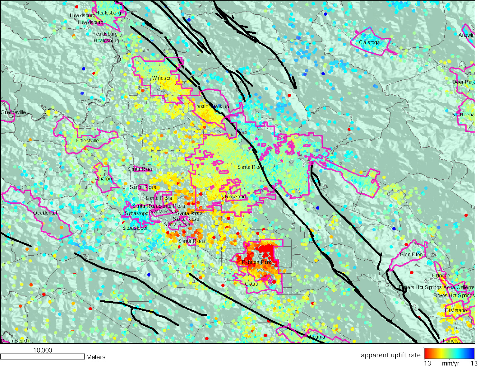
Please find attached a GIS map of incorporated settlements and surface deformation velocities.
The latter are labeled 'apparent uplift' as in InSAR measurements we have a 1D measurement in
the satellite line-of-sight which is primarily sensitive to vertical motions, but also somewhat
sensitive to E-W-oriented motions. (Thus there is a component of horizontal deformation, which is
due to accumulation of strain on the regional strike-slip faults, such as the San Andreas and
Rodgers Creek faults, which can look like uplift.) The subsiding areas are the areas marked with
red spots. The largest line-of-sight velocities are of the order of 10 mm/yr with respect to
neighboring areas; converted to a vertical rate, this is equivalent to a 13 mm/yr maximum
subsidence rate; the median subsidence rate in those areas is around 8-9 mm/yr.

The magenta areas are the boundaries for incorporated settlements in the region. (The density of
our observations tends to be greatest in these areas, as buildings are the best reflectors for
InSAR.) As you can see, one of the subsiding areas is almost wholly within the city boundaries of
Rohnert Park; the other lies mostly within unincorporated areas between Sebastopol and Santa
Rosa. As I mentioned in my earlier message, we are not exactly sure of the relative importance of
shallow sediment settling/compaction effects and subsidence due to groundwater extraction in
the case of the Rohnert Park subsidence, although I imagine borehole and well-level data from
those areas would provide some constraints.


What's the timeline look like?

>The entire hydrologic history of the Santa Rosa Plain Groundwater Basin shows massive overdraft. The USGS warned planners in the area in 1972 that well yields were insufficient for municipal use.

>In 1982, The California Department of Water Resources mapped a gigantic cone of depression under Rohnert Park showing the water table had dropped 150 feet in 25 years.

>In July, 2006 The O.W.L. Foundation won the first SB 610 suit in the state against Rohnert Park.Rohnert Park had attempted to counter the entire hydrologic history of the area with a contrary study ruled legally invalid by this trial judge.

>May, 2007, The O.W.L. Foundation lodges official complaint with the California State Board of Geophysicists and Geologists against AES geologists who prepared water estimates for the proposed Stations Casino project; the chief evidence was Rohnert Park’s legally invalid water supply assessment.

> In 2007, Gareth Funning. et. al. published data from two InSAR satellites showing an immense deformation under Rohnert Park. This study showed that the area is sinking at a velocity of 13 mm a year and is consistent with groundwater overpumping.

>February 27, agents of the Federated Indians of Graton Rancheria, Stations Casino's partners, told the Sonoma County Water Coalition that although the tribe would attempt to implement “green” technologies, nothing anyone did would stop FIGR from getting water because they would exercise their federal water right (also known as a “super right”).


Many useful links in the library. Click above.

O.W.L. Foundation

DONATE ON LINE!

Support your O.W.L. Foundation