|
 Weather here is cold and dry. The average max.-min. temperatures range from about 70°F (21°C) to 37°F (3°C) at the base, and from 36°F (2°C) to -26° (-32°C) in the alpine zone. Precipitation averages 4 in. (10 cm) at its base to 20 in. (50 cm) mostly as snow, along the crest. Due to the varied topography, precipitation can and does differ greatly in localized areas. Winds blowing along the crest can blow most of the snow from some areas, leaving little for trees like the bristlecone at the treeline - 11,200' (3414m). Thunder and lightning storms occur frequently in the high country. Winds are strong at the crest, both summer and winter.
The dry climate and high altitude make this region a rare environment. The rapid changes in elevation create abrupt habitat and species changes. The soil quality is poor, and at its poorest in the alpine zone. This factor combined with a short growing season, results in sparse and delicate flora. Recovery from disturbance is slow, said to take more than 100 years! This is truly an area that one must be careful in preserving.
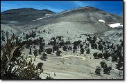
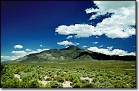
Driving along Hwy 395, and looking up at the White-Inyo range, it's appearance is somewhat barren and inhospitable, but once there we are gifted with sights and beauty unimagined from below. In August the wildflowers are abundant, the night sky clear and breathtaking; and it is so quiet here you can actually hear the wing beats of small birds! The bristlecones are reason enough to travel here, and with the abundant flora, wildlife, and vistas, we are compelled to return.
|
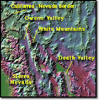 of the Sierra Nevada located a few miles west across the deep Owens Valley. As Pacific storms move eastward, the Sierra simply takes the majority of moisture, leaving the White Mountains with strong dry winds. Annual precipitation is less than 12 inches (30cm), most of which arrives as snow in winter. On a summer's day the amount of precipital moisture in the air is about half a millimeter, the lowest ever recorded anywhere on earth. But these very hardships contribute to these mountains bringing forth trees so beautiful, so ancient they surpass the majestic Giant Sequoia of the Sierra by more than a millennium!
 Owens Lake area, a distance of 110 miles (179km).
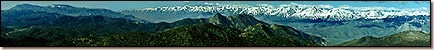
The mountains here rise from valleys on the east and west. The separation point between the White and Inyo mountains is placed at the Westgard Pass road (Hwy 168) a division with no geographic importance. This range reaches its greatest width (22 mi / 36km) east of Bishop. The rise from the Owens Valley floor at 4,000' (1219m) to elevations of more than 14,000' (4342m) is abrupt, occurring within a 12 mile (19.5km) line. These ranges have more ties with plants and animals to the east in the Great Basin, than their close neighbor the Sierra Nevada, only 10 miles (16km) westward.
Owens Lake area, a distance of 110 miles (179km).
The mountains here rise from valleys on the east and west. The separation point between the White and Inyo mountains is placed at the Westgard Pass road (Hwy 168) a division with no geographic importance. This range reaches its greatest width (22 mi / 36km) east of Bishop. The rise from the Owens Valley floor at 4,000' (1219m) to elevations of more than 14,000' (4342m) is abrupt, occurring within a 12 mile (19.5km) line. These ranges have more ties with plants and animals to the east in the Great Basin, than their close neighbor the Sierra Nevada, only 10 miles (16km) westward.